Lake Wānaka begins receding - boaties warned

Tony O'Regan
24 October 2025, 12:55 AM
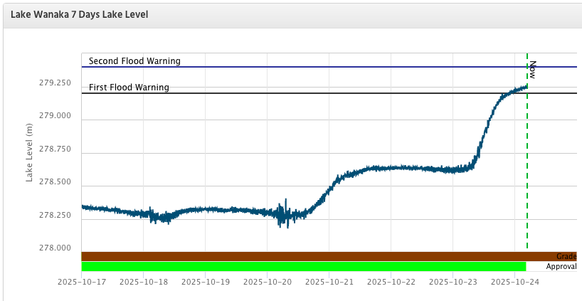 The level of Lake Wānaka peaked early this morning. IMAGE: ORC
Lake Wānaka continued to rise overnight following a week of heavy rain, passing the first flood alert level of 279.20 metres above sea level (masl). The lake peaked at 279.258 masl at 5.20am today (October 24).
Queenstown Lakes District Council (QLDC) said the level is expected to gradually recede, despite some rain forecast over the long weekend.
A clean-up is underway along the foreshore, where large amounts of driftwood have washed ashore.
The Queenstown Lakes District Harbourmaster has urged boaties to exercise extreme caution due to significant debris in the lake, including logs and trees, much of which floats just below the surface.
State Highway 6 has reopened between Maungawera and Lake Hāwea after a 24-hour closure caused by fallen trees from high winds.
Haast Pass and Mt Aspiring Rd (beyond the Treble Cone turn-off) remain closed.
The largest flood in Lake Wānaka in the past 50 years occurred in 1999, when a melting snowpack combined with heavy rain flooded lower Helwick Street and lower Ardmore Street, affecting several businesses. At that time, the lake was two metres higher than this morning’s peak, reaching 281.3 masl.
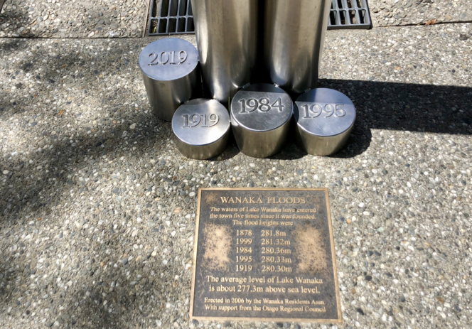
Six stainless steel markers outside Kai Whakapai record the dates and heights of the six most notable floods of central Wānaka. PHOTO: Wānaka App
Lake Wānaka has a total catchment area of 2,628 km², fed by the Matukituki and Makarora Rivers, and drains through a single outlet, the Clutha River. Despite its large catchment, the lake rises relatively slowly due to its expansive surface area.
PHOTO: Wānaka App