Solution sought for Aubrey Road flooding

Diana Cocks
30 June 2020, 2:58 AM
 Vehicles take to the middle “shared” section of this busy arterial road to avoid ponding on Aubrey Road.
Resolving stormwater flooding issues in Wanaka is a priority for council but won’t be a quick fix.
The stormwater flooding on Aubrey Road, near the turn off to Mt Ida Place, has been an ongoing problem for years with water regularly flooding across one half of the road, making the cycle path impassable, and taking days to drain away.

The significant ponding every time it rains is such a common occurrence locals have named it Lake Aubrey on social media.
Vehicles take evasive action and cyclists using the bike path are forced to cross the road or ride head on into traffic to avoid the ponding.
“This site, along with the corner of Anderson and Aubrey, have been the recipient of dozens of requests over a long period of time and something of frustration to me as it’s clearly an unacceptable problem,” QLDC councillor and infrastructure committee chair Quentin Smith said.

The ponding even has its own Facebook page.
An increase in residential development along Aubrey Road has increased stormwater runoff significantly and when combined with “sub par construction of the intersection design at Mt Ida Place” it’s resulted in a problem for council to fix, he said.
He said the stormwater drainage along Aubrey Road is largely a “soak away type option in that swales would hold and drain water.”
Alternative solutions requiring piping stormwater away are both costly and disposal to the river or lake also poses challenges, he said.
Queenstown Lakes District Council (QLDC) chief engineer Ulrich Glasner said the council is starting a new project to expand the soak pit near the Mt Ida Place intersection this week.
The project, which is expected to take a week, will dig out the existing soak pit down to gravel levels believed to be located about three to four metres deep, where soakage testing will be carried out.
“The plan is to increase the capacity [of the soak pit] as much as reasonably practicable while on site in accordance with consultant advice,” Ulrich said.
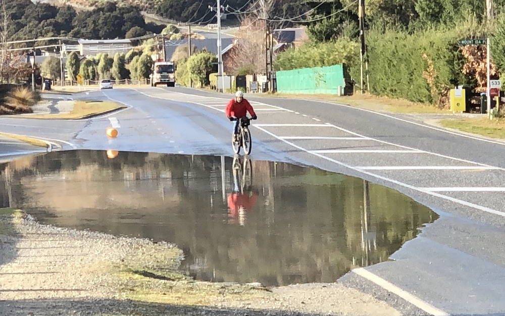
With the Aubrey Road cycleway blocked by floodwater, a cyclist takes evasive action across the road.
It seems simple but it might not be the final solution.
“We do not know with a high degree of certainty what the benefits of this approach are going to be, until the soakage testing is complete,” he said, but council will continue to monitor the situation.
Depending on the success of the soak pit, a long term solution could be added to the council’s 10-year Plan or 3 Waters projects, Ulrich said. Almost $13M has been budgeted in this year’s annual plan for spending on stormwater across the QLDC district.
The project to upgrade the Aubrey Road cycleway, including widening and sealing it from Anderson Road to Gunn Road and making safety improvements at its intersections, will not be affected by the stormwater work, he said.
Design plans for stage one of the upgrade, from Anderson Road to Mt Ida Place including the current area prone to flooding, are complete and work is scheduled to start in November 2020.