Lake Wānaka approaches alert level

Tony O'Regan
02 June 2023, 3:43 AM
 The level of Lake Wānaka has risen 1.5 metres in the past seven days.
Lake Wānaka has risen 1.5 metres in the past seven days with heavy rain last night (Thursday June 1) pushing the level to within 0.6 metres of the flood alert level (279.4 metres) set by the Otago Regional Council (ORC).
The lake is currently at 278.8 metres and while the rain has abated the MetService is forecasting more heavy rain for Sunday with snow down to 700 metres.
“The level of Lake Wānaka is expected to rise in response to the heavy rain forecast on Sunday (June 4) but at this stage it is not expected that the lake will reach a level that may result in flooding of parts of Wānaka,” ORC natural hazards/duty flood officer Dr Jean-Luc Payan said.
“ORC is actively monitoring the weather situation and river and lake levels as part of its 24/7 flood monitoring service.”
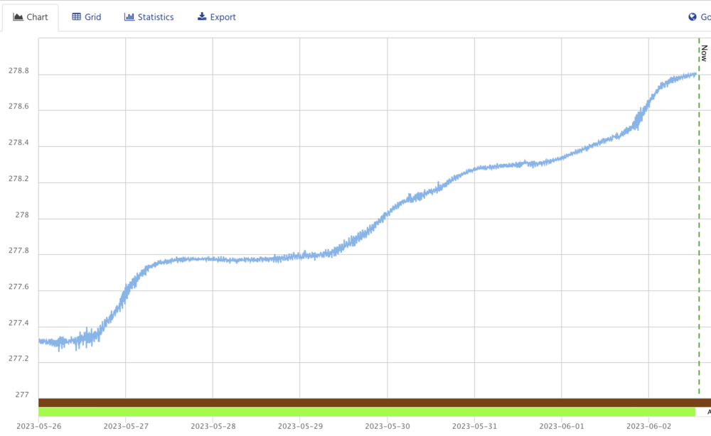
The graph shows the rapid rise of Lake Wānaka in the past week. IMAGE: Otago Regional Council
This is only the second time the lake has reached 278.8m since it last flooded in December 2019 when it peaked at 280.38m, more than 1.5 metres above its current level. At that time water encroached across Ardmore Street lapping at the doors of businesses along the lakefront.
Ardmore Street was closed and the sewerage system for central Wānaka shut off to avoid contamination, forcing CBD businesses unaffected by the flooding to close.
The biggest flood recorded in Lake Wānaka in the past 50 years was in 1999 when a melting snowpack combined with heavy rain to put lower Helwick Street and lower Ardmore Streets underwater, closing a number of businesses. At that time the lake peaked at 281.3m.
Lake Wānaka has a total catchment area of 2628 km2, fed by the Matukituki and Makarora Rivers. A single outlet drains it; the Clutha River.
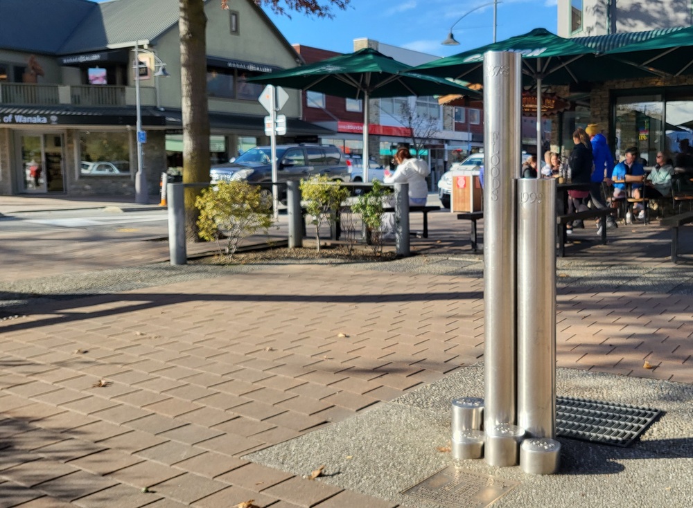
Six stainless steel markers outside Kai Whakapai record the dates and heights of the six most notable floods of central Wānaka.
Despite its large catchment Lake Wānaka rises relatively slowly due to its large surface area. This characteristic means that the development of a flood event can be reliably monitored and the community afforded long-lead times; typically several days.
If Wānaka’s lake level reaches 279.4m a first warning is triggered and council begins communicating with businesses and residents that could be affected by a flood, encouraging them to start implementing their own flood management plan.
Otago Civil Defence Emergency Management provides advice on preparing and responding to a flood event here.
PHOTOS: Wānaka App